Google Mobile Blog |

| “Download map area” added to Labs in Google Maps for Android Posted: 07 Jul 2011 06:00 AM PDT One way we bring you new product features is through Google Labs—a collection of fun, experimental features you can turn on if you're interested in the functionality. In fact, Google Maps itself started as a lab. In addition to our desktop Maps Labs, Google Maps for Android has a few tricks you can try out right from your phone. We'd like to introduce you to one new experimental feature, "Download map area," but also remind you of two other ones we already have: "Scale bar" and "Measure." Download map area When you're visiting an unfamiliar location, Google Maps for mobile is great for getting an idea of how close you are to your destination, where streets and landmarks are in relation to each other, or just for getting "un-lost." But what if you don't have a data signal, or you're abroad and don't have a data plan? We say that if you use Google Maps for mobile, you'll never need to carry a paper map again. The "Download map area" lab in Google Maps 5.7 for Android is a step in making that statement true even when you're offline. Let's say later you're visiting Bordeaux during a trip to France. If you were to open Google Maps for mobile and zoom into Bordeaux without data coverage or wifi, you'd see the image on the left: 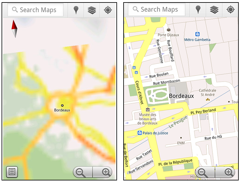 That's not particularly useful when you're trying to find out how close you are to the Cathedrale St. Andre. But a little advance planning and "Download map area" can help. Before you take your trip, while you still have access to WiFi or data coverage, you can open up any Places page in the world, click "More" to get the Place page menu, and download Google's maps for a 10-mile radius. 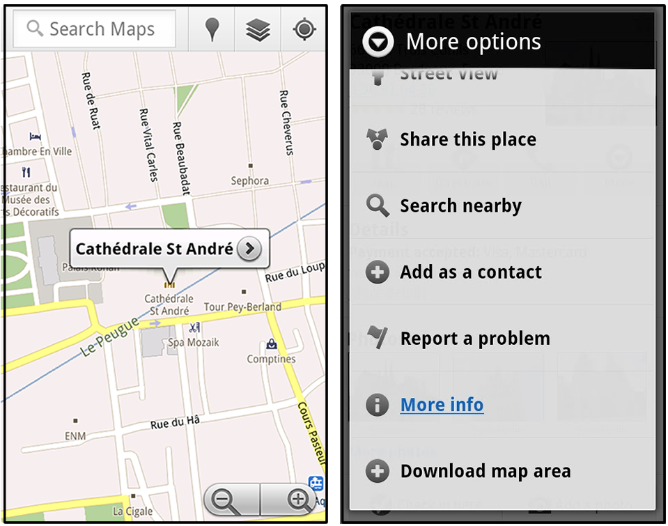 The download can take as little as a minute or two. This download stores only the base map tiles and the landmarks on the map, so you still need a data connection to see satellite view and 3D buildings, search for Places and get directions. But we hope the level of detail available will help you find your way!  All your downloaded map areas can be managed in your Google Maps cache settings so you can delete maps you no longer need or if you want to free up storage. After 30 days, all downloaded map areas will be removed from your cache; they can be re-downloaded any time. Scale bar Google Maps has approximately 20 different zoom levels that range from a 2,000 mile scale to a 20 foot scale. With finger gestures making it really quick and easy to zoom in and out, sometimes it's not always clear what zoom level you're at. What might be just a few streets away can be quite a long walk depending on the scale. To help with this, you can turn on a scale bar, which updates based on your zoom level.  Measure If you ever need to know the distance between San Francisco and New York (about 2602 miles) or between any other two points on the map, the "Measure" lab can help you out. Once it's enabled, you'll notice a tape measure icon just above the zoom buttons. After clicking that icon, you'll be prompted to tap two points on the map and Google Maps will calculate the straight distance between those points (this direct distance is "as the crow flies"). 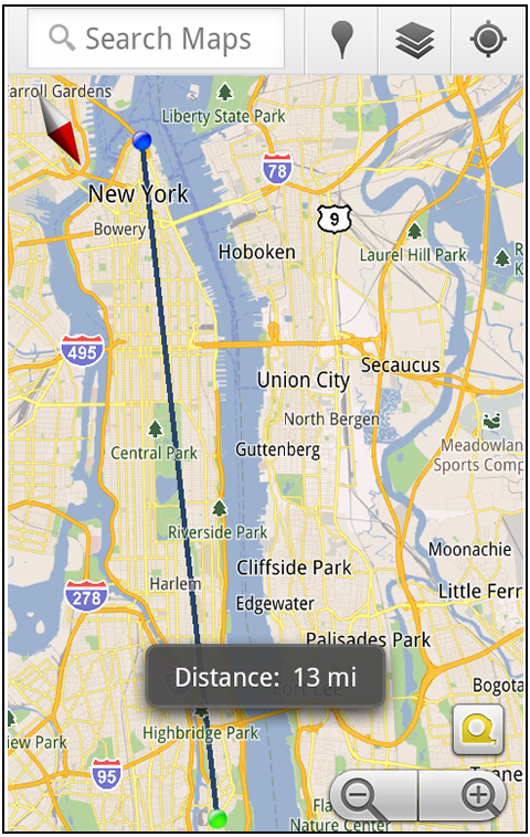 To access Labs on your phone, press your phone's menu button once in Google Maps, choose "More" and select Labs. On a tablet, click the menu button in the upper-right corner of Maps. The "Download map area" lab requires Android 2.1+ and the latest version of Google Maps. We look forward to bringing you more experimental features soon and hope you enjoy trying out Labs in Google Maps for Android. |
| Google Maps 5.7 for Android introduces Transit Navigation (Beta) and more Posted: 06 Jul 2011 09:30 AM PDT (Cross-posted on the Official Google Blog) Today we're releasing Google Maps 5.7 for Android. From Bangkok to Baltimore, we've added Transit Navigation (Beta), updated access to directions, better suggested search results, and a photo viewer to Place pages—all of which can help you whether you're traveling to an unfamiliar part of town or visiting a city across the world. Transit Navigation (Beta) Google Maps Navigation (Beta) currently provides over 12 billion miles of GPS-guided driving and walking directions per year. Now, GPS turn-by-turn (or in this case, stop-by-stop) navigation is available for public transit directions in 400+ cities around the globe with Transit Navigation. Transit Navigation uses GPS to determine your current location along your route and alerts you when it's time to get off or make a transfer. This is particularly helpful if you're in a city where you don't speak the language and can't read the route maps or understand the announcements. After starting your trip with Transit Navigation, you can open another application or put your phone away entirely and Google Maps will still display an alert in your notification bar and vibrate your phone when your stop is coming up. 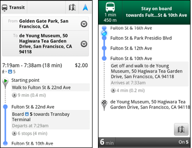  Now you can spend more time enjoying the sights out the window and less time worrying about how many stops are left, where you are along the route or whether you missed your stop. Since Transit Navigation relies on GPS signals, we recommend using this feature for above-ground transit. Updated Directions Now that we've improved our directions services, we wanted them to be incredibly easy to pull up on your screen. If you select the driving or walking icon and your route is supported by Google Maps Navigation, the Navigation icon will automatically appear so you can get access to step-by-step directions in one click. Note: this change is currently only in place for driving and walking and does not appear for public transit.  We've also streamlined how you access directions from within a Place page. Before, clicking directions in a Place page would bring up options for "Driving Navigation," "Walking Navigation" and "Directions." Now, you'll be taken straight to the map and see the new directions box shown above. Improved Search Suggest We've made two changes to search suggestions that improve their quality and speed. First, we've added category icons, so instead of all search suggestions displaying the same icon, the icon next to the listing will reflect the type of result. You'll see a pin for a Google Places listing, a star for a starred Place or location, a clock for a previously used search term, a person for contacts and a magnifying glass for "anything else."  Also, any place you got directions to or called directly from its Places page will be included as a suggestion for a relevant search. For example, if you recently received directions to the U.S. Post Office on Wilshire Boulevard, afterward, when you begin a search with [p] or [bou], that U.S. Post Office would appear as a search suggestion. Photo viewer for Place pages Since we released business photos for Place pages last October, millions of photos have been added to Place pages around the world. To enable you to view these photos on the run, a slick new photo viewer has been added so you can browse photos while deciding where to go.  To start using Google Maps 5.7 for Android, download the update here. This update requires an Android OS 2.1+ device and works anywhere Google Maps is currently available. Learn more at our help center and have fun exploring, whether it be by car, transit, bike or foot. |
| You are subscribed to email updates from Google Mobile Blog To stop receiving these emails, you may unsubscribe now. | Email delivery powered by Google |
| Google Inc., 20 West Kinzie, Chicago IL USA 60610 | |
Tidak ada komentar:
Posting Komentar